
RESOURCESAT-2 is a follow on mission to Resourcesat-1 and the eighteenth Indian Remote Sensing satellite built by ISRO.
The RESOURCESAT-2 having very similar work function as RESOURCESAT-1, but was also designed to "provide data with enhanced multispectral and spatial coverage”.
If we Compared RESOURCESAT-2 to Resourcesat-1, LISS-4 multispectral swath has been enhanced from 23 km to 70 km based on user needs.
 |
| Credit: ISRO |
Suitable changes including miniaturization in payload electronics have been incorporated in Resourcesat-2.
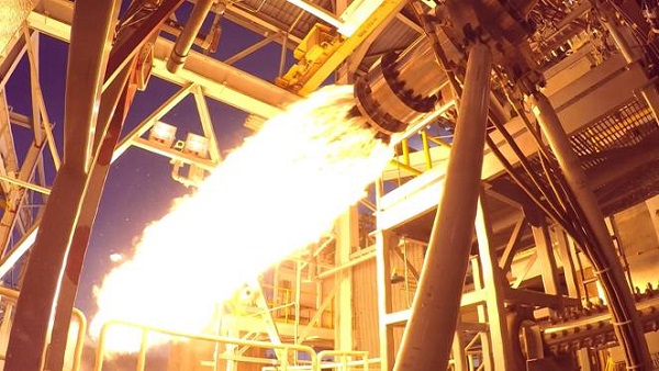
RESOURCESAT-2 along with Youthsat and X-Sat (Singapore) was launched on PSLV-C16 on 20 April 2011.
Specification:
• ResourceSat-2 is a data continuity mission of ISRO with improved spectral bands of the resources-1.
• Each RESOURCESAT-2 satellite carries three electro-optical cameras as its payload: LISS-3, LISS-4 and AWiFS.
RESOURCESAT-2 applications :
Agricultural crop discrimination and monitoring, crop acreage/yield estimation, precision farming, water resources, forest mapping, rural infrastructure development, disaster management etc.
• ResourceSat-2 provides continuity and increases the observation timeliness in tandem with resources-1.
• The spacecraft is 3-axis stabilized using reaction wheels, magnetic torquers and hydrazine thrusters.
• Attitude is sensed with star sensors, Earth sensors, and gyros. Various attitude sensors, SPS (Satellite Positioning System).
• Two-star trackers are mounted with skewed orientation on the top deck.
• The payload module, in turn, is comprised of a two-tier system, the payload module deck and the rotating deck.
Read: GSAT - 19
 |
| Credit: ISRO |
Specification:
- Advanced Wide-Field Sensor with 56-meter spatial resolution.
- The Linear Imaging Self-Scanning Sensor with a 23.5-meter spatial resolution
- S-AIS (Satellite-based Automatic Identification System) for tracking maritime traffic in Indian Ocean Search & Rescue Region
- LISS-IV Camera with 5.8-meter spatial resolution.
 |
| Credit: ISRO |
Overview:
• Mission type: Remote sensing
• Launch date: 20th April,2011
• Rocket: PSLV C16
• Manufacturer: ISRO
• Launch site: Sriharikota
• Mission duration: 5 years
• Perigee: 817 km
• Apogee: 817 km
 |
| Credit: ISRO |


0 Comments